
by Serafín López-Cuervo, Medina, Enrique Pérez Martín, Tomás Ramón Herrero Tejedor, Juan Prieto Morín, Jesús Velasco Gómez, Miguel Angel Conejo Martín, Alejandra Ezquerra Canalejo and Julián Aguirre de Mata.
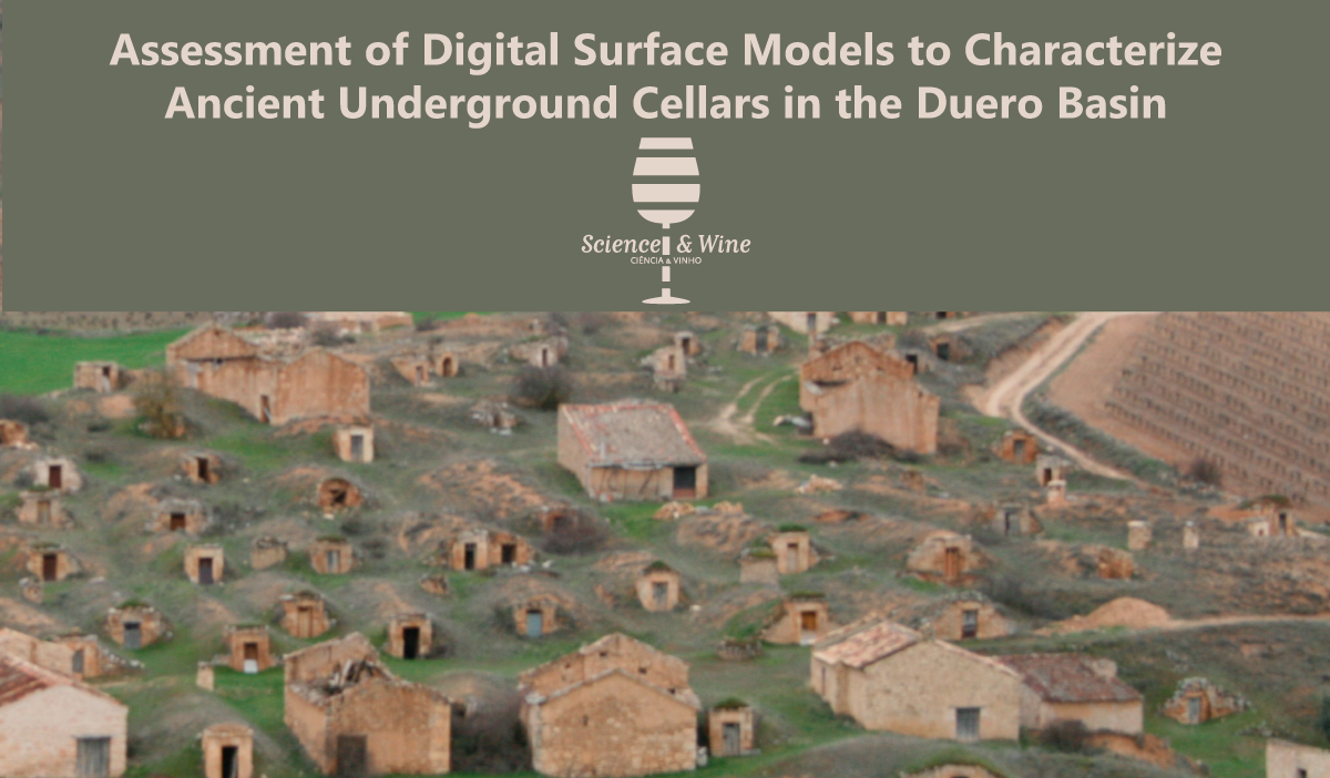
The GESYP (Geovisualization of Singular Spaces and Heritage) is working in this area since 2005 and has published several studies (https://www.youtube.com/watch?v=8YT4BkLi0EY and https://www.youtube.com/watch?v=2BYjJ-Lebn8), articles (“Assessment of underground wine cellars using geographic information technologies” (https://doi.org/10.1179/1752270614Y.0000000104), “Characterization of Cavities Using the GPR, LIDAR and GNSS Techniques (https://doi.org/10.1007/s00024-014-0985-6) and others), and phd thesis (http://oa.upm.es/30463/) around these underground cellars of El Plantio in Atauta (Soria). This area was declared an Asset of Cultural Interest (Bien de Interés Cultural, BIC) in March 2017, which represents a unique testimony of the life associated with work on the land and the traditional wine production system. In the different researches made by GESYP, the most innovated geomatics techniques in geomatics like Global Navigation Satellite Systems (GNSS), Terrestrial Laser Scanners (TLS), Unmanned Aerial Vehicles (UAV), Ground Penetrating Geo-Radar (GPR) or others were used to obtain in internal and external 3D Models of these cellars even other constructions as pigeon houses to recreate and recover this important, historical and recognized rural landscape in the Duero Basin.
In this study, there has been used a combination of Pegasus backpack-mounted mobile scanning system (MMS) and a Mavinci fixed-wing drone (UAV) to register the surface ground over the cellars. The possibility to evaluate the structural situation of the cellar roofs and the ground that cover them was an interesting target for this study. In a first instant, the researchers analyzed the data captured of both methods to stablish the precision and resolutions that could be achieved. Both systems showed different behaviors depending on their configuration and registration processes but precisions of 5cm in height in a short distance from the tracks of the MMS was achieved and similar results were obtained with UAVs. This precision was significantly reduced when the distance increased from 7.5 to 15 meters of width as demonstrated in the paper.
These first results were compared in order to define a final ground surface but the limitation of both systems in terms of obstacles and irregularities of the ground were found in this type of complex terrain. These limitations were understood such as an opportunity to combine both techniques in order to acquire and unique model of surface that combines both techniques part of the limitations found.
In the second part of the study, it was studied parameters such as the distance to the scanning point, the angles of incidence with regards to the ground, or the study of irregularities in the terrain. As a result, the combination of both data into a new model has been demonstrated as an improvement for their limitations, trying to keep the original precision of both systems by mean a selection of the points that came from the best registers of both systems.
The use of new technologies of capture like MMS or UAV reduce the cost and time of registration and allow the improvement of knowledge of the status of this kind of high value heritage areas. The use of this type of systems allows the guarantee of the conservation of important spaces such as the underground cellars of El Plantío in Atauta and what it is more important, give us better information for their recover possibilities.
The authors are part of the Geovisualization of Singular Spaces and Heritage (GESYP) Research Group:
Serafín López-Cuervo Medina
Mail: s.lopezc@upm.es
Serafín López-Cuervo Medina is phd Agronomic Engineer (1999) for the Universidad Politécnica de Madrid, Specialist on Photogrammetry and Precision Farming with extensive teaching experience developed since 1999 as Professor of Digital Photogrammetry in E.T.S.I. Topografía, Geodesia y Cartografía, Universidad Politécnica de Madrid (Spain).
Enrique Pérez Martín
Mail: enrique.perez@upm.es
Assistant Professor at Departamento de Ingeniería Agroforestal of E.T.S.I. Agronomía, Alimentación y Biosistemas, Universidad Politécnica de Madrid. He is specialist on Cartography, Geodesy, Photogrammetry and Graphic Expression Engineering and Professor of the cited School.
Tomás Ramón Herrero Tejedor
Mail: tomas.herrero.tejedor@upm.es
Associate Professor from Departamento de Ingeniería Agroforestal of E.T.S.I. Agronomía, Alimentación y Biosistemas, Universidad Politécnica de Madrid. He is specialist on Cartography, Geodesy, Photogrammetry and Graphic Expression Engineering. Today, He is the Head of the GESYP Research Group (Geovisualization of Singular Spaces and Heritage) and Associate ViceRector for Institutional Communication and External Promotion of the Universidad Politécnica de Madrid.
Juan Francisco Prieto Morín
Mail: juan.prieto@upm.es
Associate Professor of Geodesy and Geomatics in E.T.S.I. Topografía, Geodesia y Cartografía, Universidad Politécnica de Madrid. He is graduate, Msc and phD in Surveying and Geodesy engineering. His research is based on Geodesy Sciences and Geomatic and its applications on Geodesy. He is an international consultant of the World Bank (STC-HQ UPI 489473) in Geodetic Sciences.
Jesús Velasco Gómez
Mail: jesus.velasco@upm.es
Associate Professor of Geodesy and Geomatics in the E.T.S.I. Topografía, Geodesia y Cartografía, Universidad Politécnica de Madrid. He has also been Professor at Universidad Complutense de Madrid and Universidad de las Palmas de Gran Canaria. Today, he is the Dean of the E.T.S.I. Topografía, Geodesia y Cartografía, Universidad Politécnica de Madrid.
Miguel Angel Conejo Martín
Mail: miguelangel.conejo@upm.es
Associate Professor at the Departamento de Ingeniería Agroforestal in the E.T.S.I. Agronomía, Alimentación y Biosistemas, Universidad Politécnica de Madrid. He is phD Doctor and specialist on Cartography, Geodesy, Photogrammetry and Graphic Expression Engineering.
Alejandra Ezquerra Cantalejo
Mail: alejandra.ezquerra@upm.es
phD Doctor of Forest Engineering by the Universidad Politécnica de Madrid. Today, she is the Vice Dean of Academic Organization at the E.T.S.I. Montes, Forestal y del Medio Natural, Universidad Politécnica de Madrid. She is Professor of Infrastructures, transport and Forest Road, Survey and Geomatics.
Julián Aguirre de Mata
Mail: julian.aguirre@upm.es
phD Doctor by the E.T.S.I. Topografía, Geodesia y Cartografía, Universidad Politécnica de Madrid. He is specialist on Digital and Close Range Photogrammetry and Associate Professor of these areas in the same School of engineering. Today, he is the ViceDean of Studients in the same School.