By Alessandro Matese
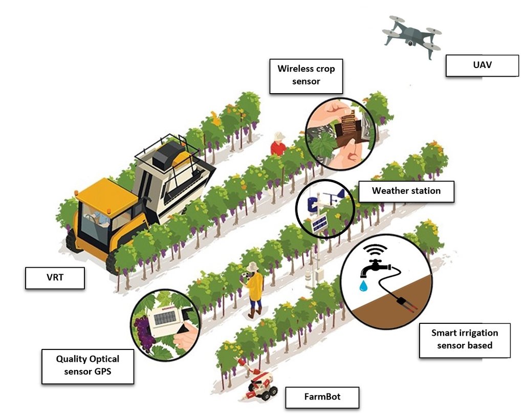
Precision viticulture is a set of methodologies, analysis and processes for a site-specific crop management. Basically, Precision Viticulture targets the spatial variability that exists in a cropping system and considers the ensemble of units that differs in terms of soil, microclimate and morphology and therefore needs to be managed in a specific way. A vineyard, especially if very extended, turn out to be the combination of many small plots cultivated with the same crop. Precision Viticulture aims at the maximization of the agronomic potential in terms of yield and of quality of productions while increasing their environmental sustainability. For instance, Precision Viticulture enhance the ability to fine-tune nutrient management decisions and develop the site-specific nutrient management plan for each vineyard and even for the single vine. Therefore, it is possible to avoid unnecessary treatments, which can be harmful and polluting, and reduce costs. As a first step, the heterogeneity in a crop must be identified and then monitored. This can be done with several technologies such as remote sensing technologies (from satellite, aircraft of drones) or proximal monitoring such as microclimatic weather stations or other sensors deployed in the field.
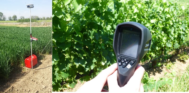
Ground optical systems, handheld cameras for temperature monitoring, infrared sensors, several sensors can be used to collect data on a given plot at high temporal resolution, providing detailed information to characterize the sub-plot variability down to the scale of the single plant. Some technologies are derived from other sectors, such as the use of drones.
The data from the different sensors have then to be organized in geo-databases and processed with geostatistical techniques, to describe plant status and the management approaches to be applied to each micro-area. All data collected is geo-localized using the GPS. This means that later, after being transferred and processed, these data can be communicated to tractors. The tractor using the GPS can distribute in different area, different quantity of fertilizer or pesticides. There are many different types of machines. For example, variable rate harvesting machines are now available, enabling the selective harvest by grape quality classes. In France a pruning tractor was developed that enables a selective pruning in function of the green biomass of each plant.
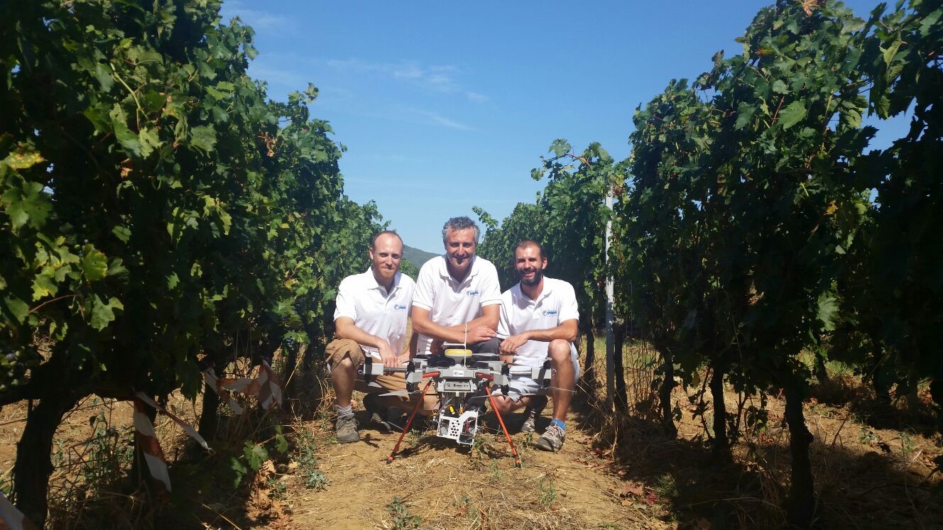
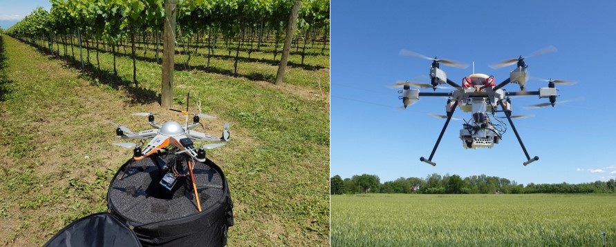
Technological development in the field of automation has provided precision viticulture with a new solution for remote monitoring, Unmanned Aerial Vehicles (UAV). These fixed or rotary wing platforms are capable of flying autonomously.
They are sometimes also improperly called “drones”, due to their monotonous low dull sound like the buzzing of a male bee. UAV can be remote controlled at visual range by a pilot on the ground, or fly autonomously to a user-defined set of waypoints, by means a complex system of flight control sensors (gyros, magnetic compass, GPS, pressure sensor and triaxial accelerometers) controlled by a microprocessor. These platforms can be equipped with a series of sensors, which allow a wide range of monitoring operations to be performed. The peculiarity of UAV application in remote sensing is the high spatial ground resolution, and the possibility of a highly flexible and timely monitoring, due to reduced planning time.
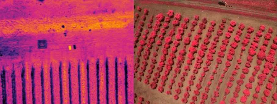
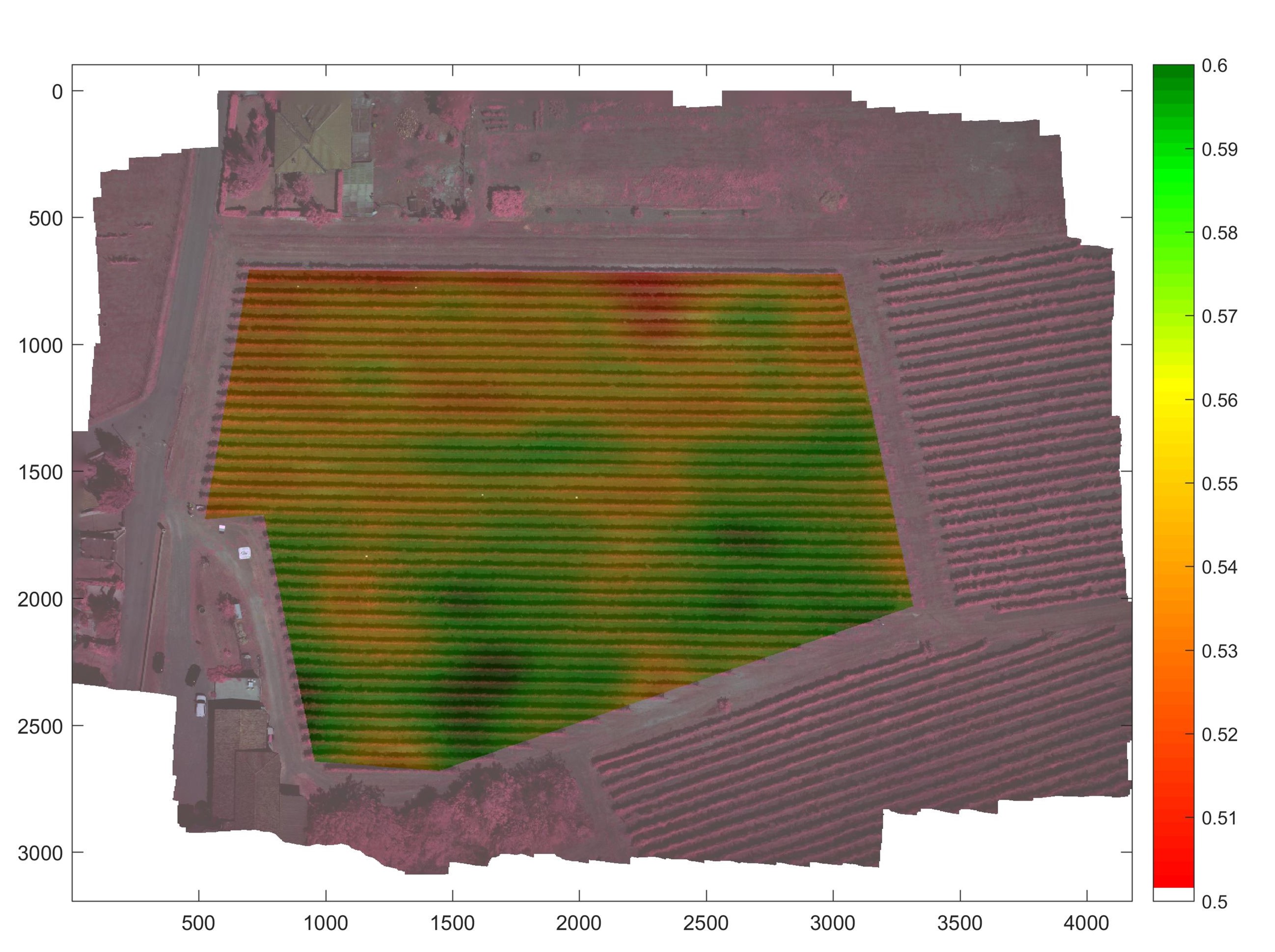
Applications of remote sensing in precision viticulture are focused mainly on reflectance spectroscopy, an optical technique based on reflectance measurement of the incident electromagnetic radiation at different wavelengths, in particular in the visible region (VIS 400-700 nm), near infrared (NIR 700-1300 nm) and thermal infrared (TIR 7500-15000 nm). The relationship between the intensity of the reflected and incident radiant flux is specific to each type of surface. The most common classes of sensors are capable of detecting an alteration of transpiration or photosynthetic activity on the leaf surface.Thermal sensors are used to remotely measure leaf temperature, which increases when water stress conditions occur, and is followed by stomatal closure, which reduces the water loss and at the same time interrupts the cooling effect of evapotranspiration. Alterations in photosynthetic activity are linked to the nutritional status, health and vigor of the plants, and can be detected with multispectral and hyperspectral sensors. Aerial images are frequently used to estimate spatial patterns in crop biomass and yield, using Vegetation Indices (VI) such as the Normalized Difference Vegetation Index (NDVI). Correlation of these indices with structural or physiological characteristics of the vine is well studied. NDVI can be related with different factors, such as the LAI (Leaf Area Index), the presence of nutrient deficiencies, water stress status or health status, while the narrow-band hyperspectral vegetation indices are sensitive to chlorophyll content.

Date of birth March 3, 1974, Florence, Italy
Position: Researcher at National Research Council – Institute of Biometeorology (CNR-IBIMET)
Education: Degree in Natural Sciences at Florence University (Italy), Department of geomorphology (1994). PhD in Agriculture, Forest and Food Science, Doctoral School of Sciences and Innovative Technologies, Torino University (Italy) (2014).
Scientific skills:
Precision agriculture and analysis of remotely sensed imagery acquired by UAS.
Spatial data analysis applied to viticulture to provide agronomic information at high spatial resolution.
Management zones delineation by multi-temporal remote sensing by UAS.
Geostatistical analysis.
Estimation of crop quality parameters by remote sensing.
Development of wireless sensor network for agricultural research and agrometeorology.
Expertise in development of high throughput field phenotyping experiments.
Development of new remote sensing technologies by UAS within precision viticulture aimed at enhancing the grapevine for quality production.
Agricultural zoning and micro-meteorological parameters monitoring for the characterization of the spatial and temporal variability of Mediterranean cropping systems (cereal production, horticulture and viticulture).
Improved processing techniques from aerial remote sensing and UAS for the vegetation indices estimation, study of eco-physiological data and development of decision support tools.
Use of modeling and computer science applied to agriculture, through specific and geographic information systems software.
Main publications:
ResearcherID: D-2268-2010; h-index: 10;
Scopus ID: 24528769900; h-index: 11;
- Matese, A., Baraldi, R., Berton, A., Cesaraccio, C., Di Gennaro, S.F., Duce, P., Facini, O., Mameli, M.G., Piga, A., Zaldei, A. Estimation of Water Stress in grapevines using proximal and remote sensing methods. 2018. Remote Sensing, Volume 10, Issue 1, 1 January 2018.
- Di Gennaro, S.F., Rizza, F., Badeck, F.W., Berton, A., Delbono, S., Gioli, B., Toscano, P., Zaldei, A., Matese, A. UAV-based high-throughput phenotyping to discriminate barley vigour with visible and near-infrared vegetation indices. 2017. International Journal of Remote Sensing, 24 November 2017, Pages 1-15
- Matese, A., Di Gennaro, S.F., Berton, A. Assessment of a canopy height model (CHM) in a vineyard using UAV-based multispectral imaging. International Journal of Remote Sensing, 2016, 38(8-10), 2150-2160.
- Santesteban, L.G., Di Gennaro, S.F., Herrero-Langreo, A., Miranda, C., Royo, J.B. and Matese, A. High-resolution UAV-based thermal imaging to estimate the instantaneous and seasonal variability of plant water status within a vineyard. Agricultural Water Management, 2016.
- E. Carrillo, A. Matese, J. Rousseau, B. Tisseyre. Use of multi-spectral airborne imagery to improve yield sampling in viticulture. Precision Agriculture, 2016, 17:74-92; doi 10.1007/s11119-015-9407-8
- Alessandro Matese, Piero Toscano, Salvatore Filippo Di Gennaro, Lorenzo Genesio, Francesco Primo Vaccari, Jacopo Primicerio, Claudio Belli, Alessandro Zaldei, Roberto Bianconi and Beniamino Gioli. Intercomparison of UAV, Aircraft and Satellite Remote Sensing Platforms for Precision Viticulture. Remote Sensing 2015, 7(3), 2971-2990; doi:10.3390/rs70302971.
- Matese, A., Crisci, A., Di Gennaro, S.F., Primicerio, J., Tomasi, D., Marcuzzo, P. and Guidoni, S. 2014. Spatial variability of meteorological conditions at different scales in viticulture. Agricultural and Forest Meteorology, Volumes 189–190, 1 June 2014, Pages 159-167.
- Matese, A., Vaccari, F.P., Tomasi, D., Gennaro, S.F.D., Primicerio, J., Sabatini, F. and Guidoni, S., 2013. Crossvit: Enhancing canopy monitoring management practices in viticulture. Sensors (Switzerland), 13(6), pp. 7652-7667.
- Salvatore Filippo Di Gennaro, Alessandro Matese, Mirko Mancin, Jacopo Primicerio and Alberto Palliotti. 2014. An Open-Source and Low-Cost Monitoring System for Precision Enology. Sensors 2014, 14(12), 23388-23397.
- Jacopo Primicerio, Salvatore Filippo Di Gennaro, Edoardo Fiorillo, Lorenzo Genesio, Emanuele Lugato, Alessandro Matese and Francesco Primo Vaccari. 2012. A flexible unmanned aerial vehicle for precision agriculture. Precision Agriculture, Volume 13, Issue 4, pp 517-523. DOI: 10.1007/s11119-012-9257-6.
- Matese, A., Di Gennaro, S.F., Zaldei, A., Genesio, L., Vaccari, F.P., 2009. A Wireless sensor network for precision viticulture: The NAV system. Computers and Electronics in Agriculture 69, 51-58.